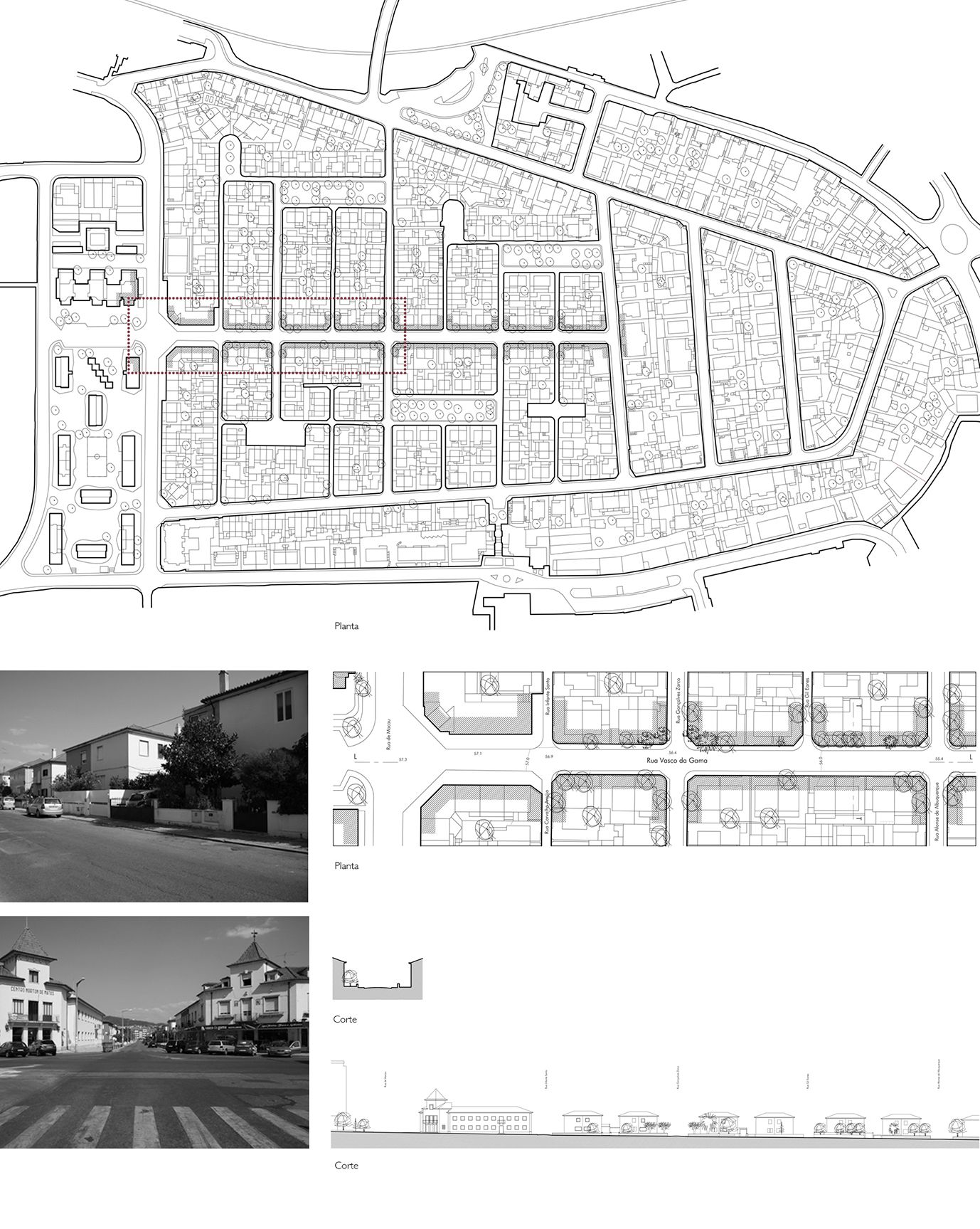
COIMBRA / Rua Vasco da Gama
The Vasco da Gama street is the structural axis, and even of symmetry, of the Norton de Matos neighborhood in Coimbra. To its east-west geographical orientation corresponds a development that we can consider flat. This unequivocal regularity has a match in the buildings that runs alongside the street, detached single-family houses with two floors, residual space (green or not) and generally uniform architectural design. This street is followed by a secondary perpendicular axis, which formally divides it into two. Each side is distributed in to four blocks north and three south. However, and except for the neighboring streets in every neighborhood just the Vasco da Gama street has a large size provided as in all the other street smallness is standard, including in the cul-de-sacs that aim to be squares. As the neighborhood the street maintains almost exclusively its residential character, but with an overwhelming presence of the automobile. For all this to speak the street you have to talk of the neighborhood and vice versa.
The Norton de Matos neighborhood only has this name since 1974, ie, the end of the Fascist Regime that created it, first with the designation of the Economic Calhabé neighborhood - the ancient place name of the area - after Marechal Carmona. It was just one of many "economic neighborhoods" ( "social" is a term for this purpose only came into use several decades later ) created by the Fascist Regime in order to solve the problems of lack of housing with minimum levels of quality in the main Portuguese cities. In 1944 the program awarded to Coimbra the possibility of creating a neighborhood with 500 homes, with the initial plan, designed by the architect Januário Godinho, only contemplating the construction and 392. With time some more were added from the peripheries whose property was conquered for the neighborhood.
The choice of the site - a hill until then covered with olive trees with a small plane in the hilltop - was made the same year and on par with the approval process of Coimbra Urbanization Plan designed by Etienne Groër. It is thus an integrated action plan, which includes relevant options for vicinity: The municipal stadium, the various schools and the Church of São José. All this would be crucial for almost immediate construction of the private urbanization of Solum, which thus completed with a relevant modern note the structuring of the most relevant centralities of the city.
However, due to its implementation and design, the neighborhood still has a close nature to the buzz of its surroundings. It was realized in a decade and in 1955 already the municipal committee of toponomy named the streets and squares, using for this the theme of the Portuguese expansion and discoveries. The highest mark that this new surrounding brought to the neighborhood and precisely to the street in question, was not achieving its perspective ends: a church to the east and a basic school to the west. These proved unnecessary due to the close offer. However they would have been important to provide the neighborhood a family feeling that in this type of neighborhoods acquired various embodiments, like we can see in the neighborhoods of Encarnação, Caselas or Alvito in Lisbon.
The design of beveled edges of the last blocks of the street to the east - produced in collective housing buildings also with two floors and not single houses, for such there exceptionally inserted – were designed in preparation for the relative monumentality intended for the church square.
